

Going One Step Ahead in Drone Imaging
DROACOR® is a software product created and maintained by ReSe Applications LLC. Ask for our free trial version for 20 days.
Features
DROACOR® can be used out of the box for supported sensor systems. The mostly automatic data import and pre-configured atmospheric correction makes it usable without expert knowledge about atmospheric compensation.

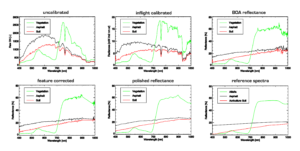
Automatic physical reflectance retrieval method

Radiation parameters from LibRadtran radiative transfer model

Temperature retrievel fo single band TIR sensors

Processing of ground based and side-looking imagery

Aerosol optical thickness estimate by enhanced dark object method

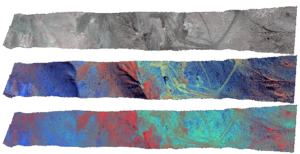
Topographic illumination correction based on digital surface model input

Optional below-cloud reflectance retrieval

Panel based inflight radiometric calibration

Built-in multi-file and simultaneous multi-product vegetation index calculation

Data visualization, evaluation and basic processing using the build-in GLIMPS tools

De-shadowing of cloud/building cast shadow areas using image-based shade detection routines.

batch processing support through the availability of an open data format and scripting environment,

Spectral recalibration for VNIR and SWIR using oxygen band positions

Automatic processing and product generation
Improved results in shaded vegetation areas
A New Generation
During the last few years, drone-borne sensors have been widely used in geology, exploration, and agriculture. Image acquisition is possible for clear and cloudy conditions and in areas difficult to access. UAV data acquisitions are often conducted over longer periods of the day. Our new generation physical approach of atmospheric correction software provides a practical solution to this problem. It improves the analysis of the series of images since ground brightness variations caused by varying illumination conditions and atmospheric influences can be compensated.
- Usable without expert knowledge about atmospheric compensation
- Reflectance retrieval consistent over time and solar position
- Improved results in shaded vegetation areas
- Enables meaningful time series analyses through coherent reflectance retrievals
- Allows quantitative index analysis using absolute reflectances
- Optimized for fully automatic processing and product generation
- Low altitude optimized adjacency radiance and irradiance correction
- Optimized for low flight altitudes (i.e. < 2 km above ground)
- Consistent image acquisitions and meta data (e.g. EXIF) required

Use Cases
Prices
DROACOR® Education
from EUR 900.- / yearGet a free evaluation license to try out this software application at no cost for 20 days. A trial version may be issued once per person upon request. It contains all the functionality of the regular version.
DROACOR® Research
from EUR 1’450.- / yearGet a free evaluation license to try out this software application at no cost for 20 days. A trial version may be issued once per person upon request. It contains all the functionality of the regular version.
DROACOR® Commercial
from EUR 2’100.- / yearGet a free evaluation license to try out this software application at no cost for 20 days. A trial version may be issued once per person upon request. It contains all the functionality of the regular version.
Testimonials
About Us
ReSe Applications LLC provides Remote Sensing Software Applications for processing of multispectral and hyperspectral images. The provided software applications PARGE®, DROACOR®, ATCOR® and MODO are designed to process remote sensing data derived from devices like Hymap, APEX, AVIRIS, NEO’s Hyspex, Specim’s AISA, Headwall Photonics Hyperspec, Resonon Pika, Itres’ CASI, and more. It builds upon IDL technology to extend remote sensing software packages like ENVI.
News
DROACOR® version 2.0 is released
DROACOR® Version 1.1 is released
DROACOR® Version 1.0 is released

Contact us
Thanks for your interest in our software products. Just let us know if you require any further information. We would be happy to help you in your remote sensing needs.

